The Ultimate June Road Trip Itinerary: Explore Iceland in 8 Days
Plan an unforgettable 8-day Iceland road trip in a camper van, from waterfalls and black‑sand beaches to ice caves, hot springs, Reykjavík and the Blue Lagoon, plus a free downloadable route map and more itineraries.
ROADTRIPTRAVEL ITINERARIESICELANDFEATURED
Iceland's shoulder season, particularly in the month of June, offers a unique experience for travelers eager to explore this stunning Nordic island. The term "shoulder season" refers to the transitioning period between peak and off-peak travel times, where visitors can benefit from a variety of factors that enhance their adventure. During June, the influx of tourists begins to rise, but it is still manageable compared to the peak summer months of July and August. Average temperatures during this month range from 10°C to 15°C (50°F to 59°F), making it suitable for outdoor exploration.
Travelers can also take advantage of extended daylight hours in June due to the midnight sun phenomenon. This natural occurrence provides nearly 24 hours of daylight, giving visitors ample time to explore popular attractions without the constraints of early sunsets. This extended period of light makes it possible to visit multiple sites in a single day, particularly during a road trip where flexibility is key.
Essential Preparation for Your Road Trip
Preparing for a road trip in Iceland requires careful planning and consideration of various factors. One of the first steps is securing the right rental car. Given Iceland's diverse terrain, a 4x4 vehicle is ideal, especially for exploring the rugged landscapes found in the highlands.
It is important to familiarize yourself with the unique road conditions, such as unpaved roads and one-lane bridges often encountered outside urban areas. Check the Icelandic Road and Coastal Administration website for real-time updates on road conditions and closures.
Furthermore, utilizing apps and resources for navigation and weather updates can significantly enhance your travel experience. Apps like Google Maps and Waze can aid in finding your way through the countryside, while Veður provides up-to-date weather information, helping you make informed decisions while on the road. These tools are invaluable for both safety and maximizing your enjoyment of Iceland's breathtaking landscapes.
For more tips about planning your trip to Iceland, check out my travel blog post HERE!

Day 1: Keflavík → Thríhnúkagígur → South Coast waterfalls → Vík
Pick up your camper van at the airport and stock up on snacks and fuel. Join Route 41 towards Reykjavík, then follow signs out towards the Bláfjöll / Blue Mountains area for your volcano tour base.
Stop 1: Thríhnúkagígur Volcano
Park at the tour base and hike across the lava field to the crater (about 40 minutes each way, on a mostly flat trail). Take the open lift down into the magma chamber for your “inside a volcano” experience, then hike back to the parking area.
Drive to the South Coast
From the Blue Mountains area, head back to the main road and join Route 1 (Ring Road) heading east towards the South Coast. You’ll follow Route 1 for most of the day, with short detours to waterfalls just off the highway.
Stop 2: Gljúfrabúi & Seljalandsfoss area
Turn off Route 1 for the Seljalandsfoss parking area. Walk first to Gljúfrabúi, the almost‑hidden waterfall tucked inside a narrow canyon. Then visit Seljalandsfoss, where a path takes you behind the falls when it’s safe and conditions are good. Nearby you can also spot smaller falls like Drífandi and Írárfoss along the same stretch.
Stop 3: Drangurinn í Drangshlíð
Continue east on Route 1 and take the short side road to Drangurinn í Drangshlíð, the turf‑covered farm buildings built into the rock. It’s a quick photo stop and a lovely peek at traditional Icelandic rural life.
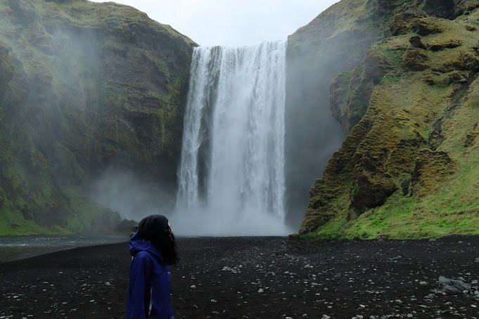
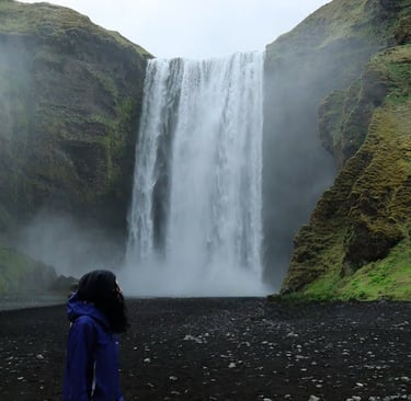
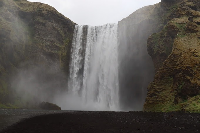
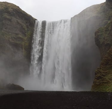
Stop 4: Skógafoss & Kvernufoss
Drive back to Route 1 and continue east to the village of Skógar. Park near Skógafoss and walk right up to the base of the falls; if you feel like a climb, take the stairs up the side for river and cliff views. For Kvernufoss, follow the trail from a nearby parking spot into a green gorge to find this quieter waterfall hidden behind a curve in the cliff. This trail is about 20 minutes one way, withn an easy but quite slippery trail.
Optional Stop 5: Sólheimasandur Plane Wreck
Head back to Route 1 and continue east until you reach the signed parking area for the Sólheimasandur Plane Wreck. From the car park it’s a long, flat walk across black sand (about 45 minutes each way) to reach the wreck – only do this if you still have time and energy.
End: Vík Camping
Finish the day by driving the last stretch of Route 1 into Vík. Check in at Vík Camping, cook a simple campsite dinner and fall asleep to the sound of the wind and waves, ready for day 2 on the South Coast.
Day 2: Vík → Katla Ice Cave → Black‑sand beaches → Canyons and Skaftafell
Pick up where you left off in Vík with a slow breakfast and a quick weather check. Today is a mix of glacier adventures, dramatic black‑sand beaches and mossy canyons, before you end the day in Skaftafell.
Stop 1: Katla Ice Cave (tour from Vík)
Join your pre‑booked Katla Ice Cave tour from Vík. You’ll usually meet in town, then jump into a super‑jeep that takes you onto the glacier area, where you’ll explore blue ice formations and walk inside the cave with a certified guide. Dress warmly and wear waterproof layers – it’s beautiful, but cold and wet under the ice.Stop 2: Voyage Vik / Voyages Friendship Statue
After your tour, stroll over to the Voyages Friendship Statue in Vík. It’s a quick stop near the harbour, but a nice way to connect with the town’s seafaring history and grab a few photos before you hit the road again.Stop 3: Víkurfjara Black Sand Beach & Reynisdrangar View
Drive the short distance to the main black‑sand beach in Vík, Víkurfjara. From here you get a great view of the Reynisdrangar sea stacks rising out of the ocean, with colourful houses and cliffs behind you. Stay well back from the water’s edge – the waves are powerful and unpredictable.Stop 4: Hálsanefshellir Cave & Dyrhólaey
Continue west along Route 1 and follow signs down to Reynisfjara and Hálsanefshellir Cave, where you can stand under towering basalt columns and watch the surf from a safe distance. Afterward, drive up to Dyrhólaey, a small peninsula with a lighthouse, sweeping coastal views and, in season, plenty of birdlife. The road up can be a little steep and rough; only go if conditions are good and you’re comfortable with the drive.Drive east towards Kirkjubæjarklaustur
Head back to Route 1 and continue east, leaving the Vík area behind and entering a more open landscape of lava fields and moss. This stretch has several great stops close to the road.Stop 5: Gígjagjá & Fjaðrárgljúfur Viewpoint
Make a brief stop at Gígjagjá, then continue to the Fjaðrárgljúfur viewpoint. From the parking area, follow the marked path along the canyon edge for different vantage points over the winding river below. The trail is easy but can be muddy and slippery in wet weather, so good shoes are a must.Stop 6: Kirkjubæjarklaustur, Dverghamrar & Foss á Síðu
Carry on to the small village of Kirkjubæjarklaustur for fuel, snacks or a quick coffee. Just beyond, stop at Dverghamrar, where strange basalt rock formations rise next to the road, and then at Foss á Síðu, a pretty waterfall cascading down a steep cliff almost right beside the highway.Stop 7: Lómagnúpur Scenic Spot
Back on Route 1, pause at the Lómagnúpur scenic viewpoint. The sheer cliff face and flat plains in front of it make for dramatic photos, especially if the clouds are hanging low around the summit.Stop 8: Skaftafell & Svartifoss
Continue east until you reach Skaftafell in Vatnajökull National Park. Park near the visitor centre and follow the well‑marked trail to Svartifoss, the waterfall framed by tall basalt columns. The hike takes about 1.5–2 hours round trip at a relaxed pace, with some uphill sections but nothing technically difficult. Take your time and enjoy the views back towards the glacier.End: Skaftafell Campground
Finish your day by checking in at Skaftafell Campground, right at the foot of Vatnajökull. Make dinner with a glacier view, charge your camera batteries and get some rest – tomorrow is all about more glaciers, lagoons and the road towards Höfn.
Day 3: Skaftafell → Glacier views → Jökulsárlón & Diamond Beach → Höfn & Vestrahorn
Start your morning in Skaftafell with a hot drink and one last look at the glacier tongues around you. Today is a big “ice and views” day as you work your way east towards Höfn and the dramatic Vestrahorn mountain.
Stop 1: Svínafellsjökull Glacier
Leave Skaftafell and drive a short distance east along Route 1 to the turn‑off for Svínafellsjökull. Follow the gravel road carefully to the parking area. From there, walk towards the glacier edge on the marked path and soak up the view of the jagged ice, deep crevasses and blue tones. It’s an easy walk, but the ground can be uneven and muddy, so sturdy shoes are helpful.Stop 2: Múlagljúfur Canyon
Continue east on Route 1 and look for the turn‑off to Múlagljúfur. The access road and trail here are more rugged; only attempt it if conditions are good and you’re comfortable driving and hiking on rough ground. The hike into the canyon rewards you with towering cliffs, waterfalls and a real “hidden gem” feeling. Plan at least a couple of hours here, and bring water and layers – it can be windy on the edges.Stop 3: Fjallsárlón Glacier Lagoon
Back on Route 1, head to Fjallsárlón, a quieter glacier lagoon just off the main road. Park up and walk down to the water’s edge to see icebergs drifting in front of the glacier tongue. You can simply admire the view from shore or, in season, join a short boat tour if you’d like to get closer to the ice.Stop 4: Jökulsárlón Glacier Lagoon & Diamond Beach
A little further along the Ring Road you’ll reach Jökulsárlón, the most famous glacier lagoon in Iceland. Park near the lagoon and wander along the shoreline, watching icebergs slowly float out towards the sea. When you’re ready, cross under or over the bridge to Diamond Beach, where those same chunks of ice wash up on the black sand and sparkle like scattered glass. Give yourself plenty of time here – it’s one of those places that’s hard to leave.Drive to Höfn
From Jökulsárlón, continue east on Route 1 through ever‑changing coastal scenery. As you approach Höfn, you’ll start to see more views of Vatnajökull and the surrounding peaks.Stop 5: Höfn town
Take a break in Höfn, a small fishing town known for its langoustine. Top up on fuel and groceries, grab a bite to eat if you’re hungry, and enjoy a short walk around the harbour area with its mountain and glacier views. It’s a nice reset before your final scenic drive of the day.Stop 6: Vestrahorn & Stokksnes
Leave Höfn and follow the coast towards Vestrahorn, the dramatic, jagged mountain that seems to rise straight out of black sand. At Stokksnes, pay the small access fee if required, then drive or walk down to the beach area. Here you’ll find dark dunes, reflective pools and some of the most photogenic mountain views in Iceland, especially in soft evening light. Take your time wandering, but keep an eye on the tide and weather.End: Vestrahorn Camping
When you’ve had your fill of photos and sea air, head to Vestrahorn Camping (or your chosen nearby campsite) to park up for the night. Cook dinner with Vestrahorn in the background, review your glacier and lagoon photos, and get some rest before you start weaving your way into the Eastfjords on day 4.
Day 4: Vestrahorn → Eastfjords viewpoints → Hengifoss & Stuðlagil → Skipalækur
Start the day with one last look at Vestrahorn’s sharp peaks and black dunes, then point your camper east and get ready for a quieter, more remote side of Iceland.
Stop 1: Hvalnes Lighthouse
Drive back out along the coastal road and follow Route 1 north‑east along the shoreline. Your first easy stop is Hvalnes Lighthouse, sitting above a rocky coastline with sweeping sea and mountain views. It’s a quick leg‑stretch and photo break, perfect for a calm morning start.Stop 2: Bóndavarða
Continue winding along Route 1, enjoying the fjord views and narrow, dramatic roads. Pull over at Bóndavarða, a small historical viewpoint where you can admire the surrounding peaks and get a feel for just how isolated this part of Iceland can feel. It’s an atmospheric stop, especially if the weather is moody.Stop 3: Flögufoss
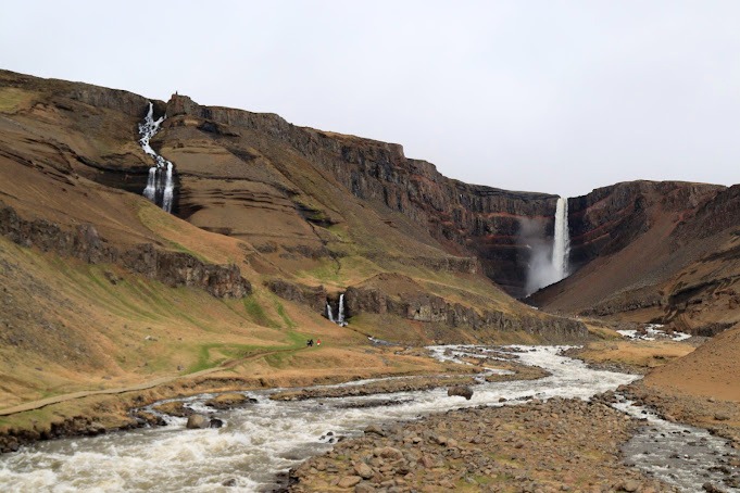
Carry on inland towards Flögufoss. The road becomes more rural here, so take it slow and watch for sheep. Park near the trailhead and walk towards the waterfall; the hike is short and not too technical, but the ground can be uneven and muddy. The falls drop into a scenic, enclosed valley that feels wonderfully off the beaten path.Stop 4: Hengifoss
From Flögufoss, drive towards Hengifoss, one of Iceland’s tallest waterfalls. Park at the main car park and follow the well‑signed trail uphill. The hike takes around 1.5–2 hours round trip, with steady climbing and several viewpoints along the way, including the smaller Litlanesfoss framed by basalt columns. At the top, Hengifoss tumbles down a cliff striped with red and dark layers – it’s a striking sight and worth the effort.Stop 5: Stuðlagil Canyon & Jökulsá á Dal viewpoint
Back on the road, head towards Stuðlagil Canyon, famous for its towering basalt columns and milky‑blue river. There are a couple of different access points; the viewing platforms offer a great look down into the gorge without a long hike. Take your time exploring different angles, then make a final brief stop at a Jökulsá á Dal viewpoint to appreciate the river cutting through the landscape.End: Skipalækur Campground
Finish the day by driving on to Skipalækur and checking into the campground. This is a good spot to recharge, do a bit of laundry if needed, and rest up after a full day of waterfalls and canyons before you push further into the north on Day 5.
Day 5: Skipalækur → Rjúkandi → Dettifoss & Mývatn area → Geosea → Camping 66.12 NORTH
Day 5 takes you from the east into north‑east Iceland, with powerful waterfalls, volcanic landscapes and a relaxing hot‑pool finish.
Stop 1: Rjúkandi Waterfall
Head out along Route 1 and make an early stop at Rjúkandi, a pretty roadside waterfall that’s perfect for a quick stretch. It’s easy to reach from the parking area and gives you an immediate “welcome to the north” feeling.Stop 2: Dettifoss
Continue towards Dettifoss, often described as Europe’s most powerful waterfall. Follow the signs to the parking area (note that access roads and sides of the falls can vary with conditions). From the car park, walk the marked paths to the viewpoints and feel the ground shake a little under your feet as the water thunders past. Expect spray, uneven terrain and some crowds in high season, but it’s absolutely worth it.Stop 3: Hljóðaklettar & The Lava Church area
Drive a short distance to the Hljóðaklettar and Lava Church area, where unusual basalt formations and echoing rock walls make for a slightly surreal stroll. Follow the trails that suit your time and energy; even a short walk here gives you a good sense of the strange shapes and acoustics that make this spot famous.Stop 4: Krafla
Head towards the Krafla geothermal and volcanic area, where you’ll see a mix of crater lakes, steaming vents and the nearby power station. Park and walk to viewpoints over the crater – the colours in the water and surrounding ground can be incredible on a clear day.Stop 5: Grjótagjá Cave
Continue to Grjótagjá, a small lava cave hiding a steamy blue pool. Bathing is no longer allowed here, but peeking into the cave is still a fun stop and gives you a sense of how Icelanders once used natural hot springs as hidden baths.Stop 6: Skútustaðagígar – Lake Mývatn pseudocraters
Drive around Lake Mývatn to Skútustaðagígar, where you can walk among the pseudocraters and look out over the wetlands. The trails are fairly gentle and offer plenty of spots to stop, watch birds and take in the calm lakeside scenery.Stop 7: Geosea – Húsavík
From the Mývatn area, head north to Húsavík and reward yourself with an evening soak at Geosea, the geothermal sea baths overlooking the fjord. Slip into the warm pools, look out over the water and let your legs recover after a packed day.End: Camping 66.12 NORTH
After your soak, drive the short distance to Camping 66.12 NORTH and settle in for the night. This is a great spot to wind down under a big northern sky before more waterfalls and coastal views tomorrow.
Day 6: Camping 66.12 NORTH → Öxarfjörður view → Goðafoss → Akureyri & north‑west coast → Sælukotið Árblik
Today you swing through some of north Iceland’s highlights, mixing famous waterfalls, a small city and remote coastal viewpoints.
Stop 1: Öxarfjörður – point of view
Set off and drive to a viewpoint over Öxarfjörður, where you can pull over and take in the wide fjord and surrounding hills. It’s a peaceful way to start the day and a reminder of how varied Iceland’s coastline is.Stop 2: Goðafoss Waterfall
Continue towards Goðafoss, the “Waterfall of the Gods”. Park in one of the designated areas and explore both sides of the falls via the paths and bridges. The water drops in a graceful semi‑circle, and it’s easy to find multiple angles for photos without long hikes.Stop 3: Akureyri
Drive on to Akureyri, Iceland’s second city and the “capital of the north”. Park near the centre and wander through the compact streets; pop into cafés, check out the church overlooking the town, and, if you have time, stroll through the botanical gardens. This is a good place to refuel, shop for supplies and enjoy a slightly more urban atmosphere.Stop 4: Sauðárkrókur Black Beach
Leave Akureyri and make your way towards the north‑west coast, stopping at Sauðárkrókur Black Beach. It’s a quieter, less visited spot, ideal for a short walk along the sand with mountains in the distance.Stop 5: Ketubjörg Cliffs & Ketubjörg Waterfall
Continue to the Ketubjörg area, where cliffs drop dramatically into the sea. From the nearby lookout, you can also see Ketubjörg Waterfall, plunging from the cliff edge. Take care near cliff edges here – stay behind any barriers and avoid getting too close to unstable ground.Stop 6: Kálfshamarsvík
Drive on to Kálfshamarsvík, a small headland filled with basalt formations and a photogenic lighthouse. The hexagonal columns and coastal views make this a fantastic place for a wander, especially in soft evening light.Stop 7: Hvitserkur
Next, head to Hvitserkur, the 15‑metre sea stack that looks like a stone creature drinking from the ocean. Park at the viewpoint and walk down towards the beach if conditions allow, keeping an eye on the tide. It’s a fun spot for photos and a nice reminder of how playful geology can look.End: Hvammstangi & Sælukotið Árblik
Finish the day by driving to Hvammstangi, a small village on the Vatnsnes peninsula, then on to your campground at Sælukotið Árblik. Make dinner, enjoy the quiet countryside and get some rest before you head to Snæfellsnes on Day 7.
Day 7: Sælukotið Árblik → Snæfellsnes viewpoints & waterfalls → Hvammsvik → Hjalli Kjós
Day 7 is a big loop around the Snæfellsnes peninsula, sometimes called “Iceland in miniature” because it has a bit of everything.
Stop 1: Álftafjörður Viewpoint
Drive south‑west towards the peninsula and pause at Álftafjörður for your first proper fjord views of the day. It’s a simple pull‑off spot but a great place to get your bearings and plan your photo stops.Stop 2: Kolgrafarfjörður Viewpoint
Continue along the road to Kolgrafarfjörður, another scenic viewpoint where you can look down on the curving fjord and surrounding peaks. Depending on the season, this area can be rich in birdlife.Stop 3: Grundarfoss & Kirkjufellsfoss/Kirkjufell
Carry on to Grundarfoss, a tall, elegant waterfall reachable by a short, easy walk from the parking area. Then head to the star of many Iceland photos: Kirkjufellsfoss with Kirkjufell mountain in the background. Wander around the paths to find your favourite angle and give yourself time to simply enjoy the setting, not just rush the photos.Stop 4: Búlandshöfði & Bugsfoss
Drive further around the peninsula, stopping at Búlandshöfði for an elevated viewpoint over water and mountains. Make a brief stop at Bugsfoss, another smaller scenic waterfall, if time and energy allow.Stop 5: Snæfellsjökull National Park – Lóndrangar & Rauðfeldsgjá Gorge
Enter Snæfellsjökull National Park and head for Lóndrangar, where two basalt towers stand guard over the sea. Short trails lead to coastal viewpoints with crashing waves and bird cliffs. Then drive to Rauðfeldsgjá Gorge, a narrow crack in the mountain where you can follow the stream into the gorge (how far you go depends on conditions and your footwear – it can be wet and slippery).Stop 6: Snæfellsjökull Viewpoint & Ytri Tunga
Continue to a Snæfellsjökull viewpoint to take in the glacier‑topped volcano from a distance. Then drive on to Ytri Tunga beach, known for its resident seals. Walk along the sand and scan the rocks for them, keeping a respectful distance.Stop 7: Ölkelduvatn Mineral Spring & Bara Borgarnes
On your way off the peninsula, stop at Ölkelduvatn mineral spring to taste the naturally carbonated water straight from the ground. Then continue towards Borgarnes and treat yourself to a meal or drink at Bara Borgarnes, a cosy stop to break up the driving.Stop 8: Hvammsvik Hot Springs
Finish the sightseeing portion of the day at Hvammsvik Hot Springs, a beautiful complex of warm pools right on the fjord. Soak, watch the light shift over the water and let your body relax after a packed schedule.End: Hjalli Kjós Camping
After your soak, drive the short distance to Hjalli Kjós camping farm and settle in for the night in the peaceful countryside, ready for a more classic “Golden Circle and city” day tomorrow.
Day 8: Hjalli Kjós → Golden Circle loop → Sky Lagoon → Reykjavík
Today you swap long drives for a tighter loop packed with Iceland’s classic sights and a spa finish.
Stop 1: Þingvellir National Park
From Hjalli Kjós, drive to Þingvellir National Park, the first stop on your Golden Circle loop. Park at one of the main car parks and explore the walking paths between the tectonic plates, viewpoints over the lake and historic sites linked to Iceland’s early parliament. The trails are mostly gentle but can be rocky and uneven in places.Stop 2: Hot spring bread stop (if available)
On your way towards the next Golden Circle stops, you may have the chance to visit a hot spring baking site, where local guides show how they bake bread in the warm ground. If you’ve booked that experience, plan enough time for a short demonstration and tasting.Stop 3: Geysir Geothermal Area
Continue to the Geysir geothermal area, where you’ll find hot pools, steaming vents and the ever‑reliable Strokkur geyser. It erupts every few minutes, so you don’t need to stress about timing – just pick a safe spot, wait for the build‑up and enjoy the show.Stop 4: Gullfoss Waterfall
Drive a short distance to Gullfoss, one of Iceland’s most famous waterfalls. From the parking area, follow the paths to different viewing platforms above and beside the falls. The power of the water and the shape of the canyon make this one of the most impressive stops on the loop.Stop 5: Kerid Crater
On the way back towards the coast, stop at Kerid Crater, where a colourful lake sits inside a red‑rock volcanic bowl. Walk around the rim for changing perspectives, and, if you like, take the steps down to the water’s edge.Stop 6: The Geothermal Park – Hveragerði
Continue to Hveragerði and the geothermal park, where you can see bubbling mud pools and steaming vents right in town. It’s a compact stop but gives a great sense of how active the ground is in this area.Stop 7: Sky Lagoon
From Hveragerði, drive towards Reykjavík and finish the day at Sky Lagoon, just outside the city. Soak in the warm infinity‑edge pool, follow the seven‑step ritual if you’d like, and watch the light over the ocean. It’s a perfect way to mark the “almost end” of your road trip.End: Reykjavík
After your spa session, drive into Reykjavík, find your accommodation or campsite, and enjoy an evening in the city – maybe with a casual dinner and a short stroll along the harbour.


This itinerary covers the majority of the attractions you can drive to in Iceland in less than 10-Days. If you have extra time before your flight, pop into Grindavík for a quick look around this small fishing town or a final meal. Otherwise, you can linger at the Blue Lagoon café or just relax in the spa area before your departure!
When it’s time, drive the short distance back to Keflavík Airport, return your camper or rental car and check in for your flight. As you board, you’ll have waterfalls, glaciers, black‑sand beaches and hot springs all packed into your camera roll – and your memory!
Dont forget to follow along if you liked this post!

Travel Inspirations
by 500 Miles Away